Ground penetrating radar provides critical insight for maintaining Canada's aging roads and bridges

Municipalities across Canada are burdened with aging transportation infrastructure, much of which was constructed in the post-war era and is nearing the end of its useful life. The 2016 Canadian Infrastructure Report Card (CIRC) found that one third of municipal infrastructure across the country is in fair, poor or very poor condition, and this includes 39 percent of roads and 26 percent of bridges. Cold weather and the use of corrosive de-icing salts further threaten the reliability of the transportation infrastructure we rely on every day.
The estimated replacement value of these roads and bridges is upwards of $380 billion, and municipalities are responsible for covering 60 percent of their own costs. As such, finding cost-effective, efficient condition assessment tools and techniques has become vitally important. Municipalities are now looking beyond traditional methods to assess road and bridge conditions and strategically prioritize maintenance and rehabilitation activities.
Gaining insights with GPR
From 2006 to 2015, the second Strategic Highway Research Program (SHRP2) was launched south of the border as a mechanism to find strategic solutions to three national transportation challenges: highway safety, congestion, and bridge and road renewal. The report concluded that non-destructive condition assessment significantly reduces the overall resources and expenditures required for bridge and road renewal. It also concluded that capturing data via non-destructive methods helps to prevent premature, unexpected failure.
Ground Penetrating Radar (GPR) ranked highest in overall value for assessing bridge deck deterioration based on accuracy, precision, speed, ease of use and cost. GPR is a technology that transmits high frequency radio waves into the ground or structure and analyzes the reflected velocity and energy to create a profile of the subsurface features. The reflections are caused by a contrast in the electrical properties of subsurface materials which can be indicative of changes in water content, void spaces in the ground or structure, rebar or post tension cable corrosion, asphalt deterioration and other factors.
By revealing the complex substructure of a road or bridge, GPR can detect anomalies between coring locations, and allow project stakeholders to achieve a continuous profile of subsurface conditions. As an added benefit, fewer core samples are required because they can be strategically placed based on the GPR results - for example, in areas where the road or bridge appears to be in the worst condition. Dan Conte, Senior Bridge Engineer for URS Canada (an AECOM company) explains:
"GPR evaluation provides an additional dataset that can be cross-compared and correlated with results from traditional condition survey techniques. This makes it possible to readily identify locations of suspected deterioration and therefore target areas where destructive or intrusive sampling should be carried out during follow-up condition surveys."
Once a GPR survey is complete, reports illustrating the internal condition of a road or structure can be generated in many formats, including plan maps, colour contour maps and 3D. This information can then be integrated into a GIS or CADD-based system for reference years down the line, so that patterns of deterioration can be evaluated over time.
Rehabilitating roads in our nation's capital
GPR has been applied on multiple highways and roads across the City of Ottawa and surrounding area, including Highway 417 which connects Montreal with Ottawa and is considered the backbone of the transportation system in the National Capital Region. The technology has been applied to assess road structure, pavement, concrete and asphalt thickness in order to inform strategic decision-making around improved driving surfaces, localized repairs, and accessibility improvements and updates.
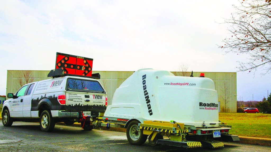
GPR surveys were carried out using a ground-coupled, high-speed system that allows for surveying up to 1.5 metres in depth and incorporates real-time GPS synchronization. Survey profiles and reference stations for the data acquisition were established according to the customer's base maps and project requirements. Data was collected at posted travel speeds, eliminating the need for traffic disruption or road closures.
Data collected in the field was digitally recorded and backed up on site. The data was then processed and analyzed to determine the average thickness of pavement, concrete and asphalt subgrade layers. Results were presented in scaled and referenced colour contour maps along with plan and sectional views of the road and bridge structures. Statistic summary tables were also provided that depicted average, maximum and minimum estimated thicknesses.
Preserving Toronto's main artery
The City of Toronto's Gardiner Expressway serves as the main artery into the City, stretching 18 kilometres from the Don Valley Parkway to the Queen Elizabeth Way (QEW). In operation since 1955, structural concerns have required sections of the Highway to be rehabilitated and, in some cases, replaced.
To get an accurate picture of the Expressway's condition, GPR was used to map bridge deck deterioration over a vast, geometrically complex area. All continuous east and westbound lanes of a 6.1 km raised section were analyzed, along with access ramps. High-resolution GPR observations were collected during an overnight survey from curb to curb, less than a metre apart at a speed of 60 kph, so traffic flow was only minimally disrupted. Six lines of data were captured for each vehicle lane and over 1.3 million targets within the project area were processed and georeferenced to assess deterioration.
Data was then digitally recorded to produce colour-coded contour maps for each section of the highway. A bridge deck deterioration index was also developed that indicated the percentages of each section appearing to be above the deterioration threshold. To ensure accuracy, data was correlated with known structure information, including existing coring data. Dr. Peter Annan, P.Eng, Ph.D, Founder of Sensors & Software, explains:
"Non-destructive technology has the unique ability to detect deterioration and other subsurface anomalies before they develop into serious concerns. Techniques such as GPR reveal changes in subsurface properties that allow suspicious areas to be targeted for further evaluation and preventative remediation. Many traditional methods of inspection will detect deterioration only once the concrete or bridge deck has already become cracked or delaminated."
Maintaining safer bridges
As part of a coordinated bridge maintenance and rehabilitation program, GPR was applied to assess the condition of various bridges connected to the Queen Elizabeth Way (QEW) highway from Mississauga to St. Catherine's, a stretch of approximately 90 kilometres. The objective of the survey was to determine the condition of concrete decks, pinpoint areas of potential deterioration and delamination, and confirm the thickness of concrete slabs below the asphalt surface.
The client was provided with a digital geophysical interpretation report that included plan maps, cross sections and mapping profile images of the subsurface layers, and corresponding thicknesses. The report also included recommendations for follow-up testing based on areas that demonstrated deterioration and delamination. The information provided was used to support strategic decision-making around the prioritization of maintenance and rehabilitation activities.
Looking ahead
Over the next several decades, much of our municipal transportation infrastructure will be in need of costly repair and rehabilitation. Adding Ground Penetrating Radar (GPR) to the infrastructure inspection process can improve reliability and assist municipalities in planning strategically. As road and bridge defects are often not visible, particularly when a surface has been repaved, GPR has the ability to detect areas that are unusually thin or thick and identify subsurface defects below asphalt overlaid roads and structures. This is accomplished non-intrusively so that structural integrity remains intact. Furthermore, with the cost of traffic congestion estimated to be upwards of $6 billion annually for Canada's largest metropolitan areas, GPR offers the added advantage of capturing data at posted speed limits, often eliminating the need for road closures and traffic control.
Kevin Vine is president of multiVIEW Locates Inc.
Benefits of GPR
Ground Penetrating Radar (GPR) transmits high frequency radio waves into a ground or structure and analyzes the reflected velocity and energy to create a profile of the subsurface features. These subsurface features can include reinforcement bar or post tension cables, changes in water content, void spaces, rebar or post tension cable corrosion, asphalt deterioration and other factors. Benefits of GPR for bridge and road infrastructure assessment include:
• Achieve a continuous profile of subsurface conditions while minimizing the need for intrusive testing: GPR detects anomalies that exist between widely spaced core samples. Fewer cores are required because data collected by GPR fills in information gaps and provides new insights into subsurface conditions. Cores that are applied can be strategically targeted based on the GPR results, rather than randomly placed.
• Detect subsurface threats before serious issues develop: Defects and wearing reduce structural capacity over time and can lead to an eventual failure. These defects are often not visible, particularly when a surface has been repaved. GPR has the ability to detect areas that are unusually thick or thin and identify subsurface defects below asphalt overlaid roads and structures.
• Obtain a rich source of data that can be leveraged years down the line: GPR data can be combined with countless other datasets to provide a complete picture of subsurface conditions. Project stakeholders can visualize deterioration and rebar corrosion along with the position of post tension cables and other subsurface features. This supports a better understanding of lifecycle costs throughout the aging process. The GPR data can also be saved and referenced years down the line when the infrastructure is re-inspected.
• Minimize and eliminate service disruptions: With the cost of traffic congestion estimated at more than $6 billion per year across Canada's major metropolitan areas, GPR offers an advantage in that data can be captured at posted speed limits, often eliminating the need for road closures and traffic control.


